HILDA+
HILDA+ Global land use change
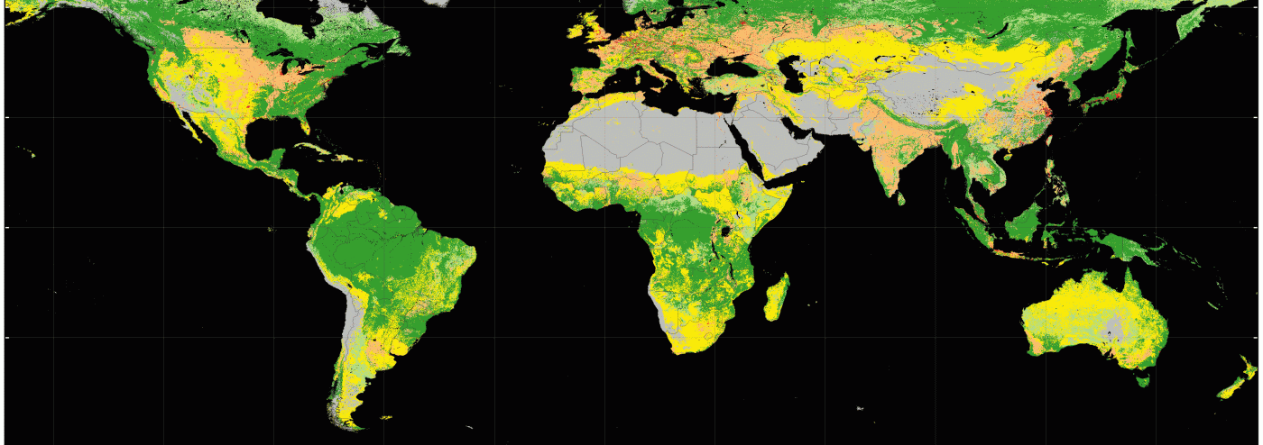
Understanding the dynamics of land use change is critical in tackling global societal challenges such as food security, climate change, and biodiversity loss. By combining multiple open data streams (remote sensing, reconstructions and statistics) we created the HIstoric Land Dynamics Assessment + (HILDA +), a global map set on annual land use/cover change in 1960-2019 at 1 km spatial resolution.
We estimate that land use change has affected almost a third (32%) of the global land area in just six decades (1960-2019) and, thus, is around four times greater in extent than previously estimated from long-term land use reconstructions.
We identify geographically diverging land use change patterns, with afforestation and cropland abandonment in the Global North and deforestation and agricultural expansion in the South.
About the HILDA+ spatial dataset:
Format: GeoTIFF and NetCDF
Projection: EPSG: 4326 - WGS 84 / ESRI: 54012- Eckert IV
Spatial coverage/extent: -180, 90, 180, -90 ° (Global)
Temporal coverage: 1960-2020 (also 1900-1960 with extrapolated trends)
Spatial resolution: 0.01° / 1 km
Temporal resolution: 1 year
Class codes: 00 ocean, 11 urban, 22 cropland (23 tree crops, 24 agroforestry), 33 pasture/rangeland, 44 forest, 55 unmanaged grass/shrubland, 66 sparse/no vegetation, 77 water, 99 no data
- HILDA+ is an Open Dataset, download it here:
Newest version https://doi.org/10.1594/PANGAEA.974335
Previous version https://doi.org/10.1594/PANGAEA.921846
- Explore the maps in an interactive viewer: https://landchangestories.org/hildaplus-mapviewer/
- Read the publications:
- Winkler, K., Fuchs, R., Rounsevell, M., and Herold, M. (2025). Six decades of global crop yield increase and cropland expansion from 1960 to 2020. Environ. Res. Commun. 7, 055013. doi: 10.1088/2515-7620/add3cd
- Winkler, K., Fuchs, R., Rounsevell, M., and Herold, M. (2021). Global land use changes are four times greater than previously estimated. Nat Commun 12, 2501. doi: 10.1038/s41467-021-22702-2
- Watch the movie: https://nextcloud.imk-ifu.kit.edu/s/idxctaFL9naKRzM
HILDA+ movie
By clicking on the button below, data is loaded from external servers.